Distance between Santo Niño and Kapatagan
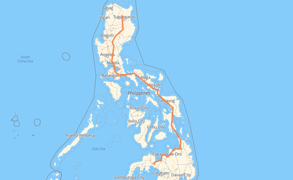
The distance from Santo Niño to Kapatagan is 1,254 miles by road including 48 miles on motorways. Road takes approximately 29 hours and 14 minutes and goes through Muñoz, Gapan, San Pedro, Biñan, Santa Rosa, Cabuyao and Calamba.
| Shortest distance by air | 706 mi ✈️ |
| Car route length | 1,253.9 mi 🚗 |
| Driving time | 29 h 14 min |
| Fuel amount | 42.6 gal |
| Fuel cost | 166.3 USD |
| Point | Distance | Time | Fuel | |
| Santo Niño | 0 mi | 00 min | 0.0 gal | |
|
AH26 210 mi, 4 h 30 min
|
||||
| Muñoz | 210 mi | 4 h 30 min | 7.1 gal | |
|
1 30 mi, 40 min
|
||||
| Gapan | 241 mi | 5 h 10 min | 8.0 gal | |
|
1 AH26 74 mi, 1 h 27 min
|
||||
| San Pedro | 315 mi | 6 h 38 min | 10.7 gal | |
|
E2 3 mi, 03 min
|
||||
| Biñan | 318 mi | 6 h 41 min | 10.7 gal | |
|
E2 4 mi, 03 min
|
||||
| Santa Rosa | 322 mi | 6 h 45 min | 10.9 gal | |
|
E2 2 mi, 01 min
|
||||
| Cabuyao | 324 mi | 6 h 47 min | 11.0 gal | |
|
E2 4 mi, 03 min
|
||||
| Calamba | 327 mi | 6 h 51 min | 11.0 gal | |
|
E2 AH26 22 mi, 26 min
|
||||
| San Pablo | 349 mi | 7 h 17 min | 11.7 gal | |
|
1 187 mi, 3 h 55 min
|
||||
| Naga | 536 mi | 11 h 12 min | 18.1 gal | |
|
1 38 mi, 51 min
|
||||
| Ligao | 574 mi | 12 h 04 min | 19.4 gal | |
|
1 50 mi, 1 h 00 min
|
||||
| Sorsogon City | 624 mi | 13 h 04 min | 21.2 gal | |
|
1 90 mi, 2 h 43 min
|
||||
| Calbayog | 715 mi | 15 h 48 min | 23.8 gal | |
|
1 52 mi, 1 h 15 min
|
||||
| Catbalogan | 766 mi | 17 h 03 min | 25.8 gal | |
|
1 62 mi, 1 h 22 min
|
||||
| Tacloban | 829 mi | 18 h 26 min | 28.1 gal | |
|
1 142 mi, 3 h 50 min
|
||||
| Surigao City | 971 mi | 22 h 17 min | 33.0 gal | |
|
1 75 mi, 1 h 36 min
|
||||
| Butuan | 1,045 mi | 23 h 53 min | 35.5 gal | |
|
9 45 mi, 1 h 12 min
|
||||
| Gingoog | 1,091 mi | 25 h 05 min | 36.9 gal | |
|
9 955 71 mi, 1 h 33 min
|
||||
| El Salvador | 1,161 mi | 26 h 39 min | 39.3 gal | |
|
9 45 mi, 1 h 13 min
|
||||
| Iligan | 1,206 mi | 27 h 52 min | 41.0 gal | |
|
9 50 mi, 1 h 21 min
|
||||
| Kapatagan | 1,256 mi | 29 h 13 min | 42.7 gal | |
Frequently Asked Questions
How much does it cost to drive from Santo Niño to Kapatagan?
Fuel cost: 166.3 USD
This fuel cost is calculated as: (Route length 1,253.9 mi) / (Fuel consumption 29.4 mpg) * (Fuel price 3.9 USD / gal)
You can adjust fuel consumption and fuel price here.
How long is a car ride from Santo Niño to Kapatagan?
Driving time: 29 h 14 min
This time is calculated for driving at the maximum permitted speed, taking into account traffic rules restrictions.
- 43 mi with a maximum speed 62 mph = 41 min
- 160 mi with a maximum speed 56 mph = 2 h 51 min
- 3 mi with a maximum speed 56 mph = 3 min
- 679 mi with a maximum speed 50 mph = 13 h 38 min
- 25 mi with a maximum speed 43 mph = 34 min
- 260 mi with a maximum speed 37 mph = 6 h 58 min
- 37 mi with a maximum speed 31 mph = 1 h 11 min
- 16 mi with a maximum speed 25 mph = 38 min
- 4 mi with a maximum speed 19 mph = 14 min
- 29 mi with a maximum speed 12 mph = 2 h 21 min
The calculated driving time does not take into account intermediate stops and traffic jams.
How far is Santo Niño to Kapatagan by land?
The distance between Santo Niño and Kapatagan is 1,253.9 mi by road including 48.5 mi on motorways.
Precise satellite coordinates of highways were used for this calculation. The start and finish points are the centers of Santo Niño and Kapatagan respectively.
How far is Santo Niño to Kapatagan by plane?
The shortest distance (air line, as the crow flies) between Santo Niño and Kapatagan is 705.9 mi.
This distance is calculated using the Haversine formula as a great-circle distance between two points on the surface of a sphere. The start and finish points are the centers of Santo Niño and Kapatagan respectively. Actual distance between airports may be different.
How many hours is Santo Niño from Kapatagan by plane?
Boeing 737 airliner needs 1 h 25 min to cover the distance of 706 mi at a cruising speed of 497 mph.
Small plane "Cessna 172" needs 5 h 9 min to flight this distance at average speed of 136 mph.
This time is approximate and do not take into account takeoff and landing times, airport location and other real world factors.
How long is a helicopter ride from Santo Niño to Kapatagan?
Fast helicopter "Eurocopter AS350" or "Hughes OH-6 Cayuse" need 4 h 44 min to cover the distance of 706 mi at a cruising speed of 149 mph.
Popular "Robinson R44" needs 5 h 24 min to flight this distance at average speed of 130 mph.
This time is approximate and do not take into account takeoff and landing times, aerodrome location and other real world factors.
What city is halfway between Santo Niño and Kapatagan?
The halfway point between Santo Niño and Kapatagan is Buhatan. It is located about 1 mi from the exact midpoint by road.
The distance from Buhatan to Santo Niño is 628 mi and driving will take about 13 h 9 min. The road between Buhatan and Kapatagan has length 626 mi and will take approximately 16 h 5 min.
The other cities located close to halfway point:
Where is Santo Niño in relation to Kapatagan?
Santo Niño is located 706 mi north of Kapatagan.
Santo Niño has geographic coordinates: latitude 17.8839, longitude 121.56929.
Kapatagan has geographic coordinates: latitude 7.89592, longitude 123.76714.
Which highway goes from Santo Niño to Kapatagan?
The route from Santo Niño to Kapatagan follows AH26, 1, 9.
Other minor sections pass along the road:
- 68: 58 mi
- 51: 57 mi
- 955: 43 mi
- E2: 32 mi
- 691: 24 mi
- E1: 14 mi
- 609: 5 mi
- 140: 3 mi
- 160: 2 mi
- 673: 2 mi
- 608: 2 mi
- 145: 2 mi
- 161: 1 mi