Distance between Natonin and Sirawai
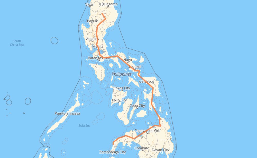
The distance from Natonin to Sirawai is 1,376 miles by road including 48 miles on motorways. Road takes approximately 31 hours and 46 minutes and goes through Muñoz, Gapan, San Pedro, Biñan, Santa Rosa, Cabuyao and Calamba.
| Shortest distance by air | 661 mi ✈️ |
| Car route length | 1,376.3 mi 🚗 |
| Driving time | 31 h 46 min |
| Fuel amount | 46.8 gal |
| Fuel cost | 184 USD |
| Point | Distance | Time | Fuel | |
| Natonin | 0 mi | 00 min | 0.0 gal | |
|
1 157 mi, 3 h 26 min
|
||||
| Muñoz | 157 mi | 3 h 26 min | 5.3 gal | |
|
1 30 mi, 40 min
|
||||
| Gapan | 188 mi | 4 h 06 min | 6.2 gal | |
|
1 AH26 74 mi, 1 h 27 min
|
||||
| San Pedro | 262 mi | 5 h 34 min | 8.9 gal | |
|
E2 3 mi, 03 min
|
||||
| Biñan | 265 mi | 5 h 37 min | 8.9 gal | |
|
E2 4 mi, 03 min
|
||||
| Santa Rosa | 269 mi | 5 h 41 min | 9.1 gal | |
|
E2 2 mi, 01 min
|
||||
| Cabuyao | 271 mi | 5 h 43 min | 9.2 gal | |
|
E2 4 mi, 03 min
|
||||
| Calamba | 275 mi | 5 h 47 min | 9.2 gal | |
|
E2 AH26 22 mi, 26 min
|
||||
| San Pablo | 296 mi | 6 h 13 min | 9.9 gal | |
|
1 187 mi, 3 h 55 min
|
||||
| Naga | 483 mi | 10 h 08 min | 16.3 gal | |
|
1 38 mi, 51 min
|
||||
| Ligao | 521 mi | 11 h 00 min | 17.6 gal | |
|
1 50 mi, 1 h 00 min
|
||||
| Sorsogon City | 572 mi | 12 h 00 min | 19.4 gal | |
|
1 90 mi, 2 h 43 min
|
||||
| Calbayog | 662 mi | 14 h 44 min | 22.0 gal | |
|
1 52 mi, 1 h 15 min
|
||||
| Catbalogan | 713 mi | 15 h 59 min | 24.0 gal | |
|
1 62 mi, 1 h 22 min
|
||||
| Tacloban | 775 mi | 17 h 22 min | 26.3 gal | |
|
1 142 mi, 3 h 50 min
|
||||
| Surigao City | 918 mi | 21 h 13 min | 31.2 gal | |
|
1 75 mi, 1 h 36 min
|
||||
| Butuan | 992 mi | 22 h 49 min | 33.7 gal | |
|
9 45 mi, 1 h 12 min
|
||||
| Gingoog | 1,038 mi | 24 h 01 min | 35.1 gal | |
|
9 955 71 mi, 1 h 33 min
|
||||
| El Salvador | 1,108 mi | 25 h 35 min | 37.5 gal | |
|
9 45 mi, 1 h 13 min
|
||||
| Iligan | 1,153 mi | 26 h 48 min | 39.2 gal | |
|
9 37 mi, 1 h 06 min
|
||||
| Ozamiz | 1,190 mi | 27 h 55 min | 40.4 gal | |
|
78 11 mi, 14 min
|
||||
| Tangub | 1,202 mi | 28 h 09 min | 40.8 gal | |
|
78 965 178 mi, 3 h 37 min
|
||||
| Sirawai | 1,379 mi | 31 h 46 min | 46.9 gal | |
Frequently Asked Questions
How much does it cost to drive from Natonin to Sirawai?
Fuel cost: 184 USD
This fuel cost is calculated as: (Route length 1,376.3 mi) / (Fuel consumption 29.4 mpg) * (Fuel price 3.93 USD / gal)
You can adjust fuel consumption and fuel price here.
How long is a car ride from Natonin to Sirawai?
Driving time: 31 h 46 min
This time is calculated for driving at the maximum permitted speed, taking into account traffic rules restrictions.
- 43 mi with a maximum speed 62 mph = 41 min
- 205 mi with a maximum speed 56 mph = 3 h 39 min
- 3 mi with a maximum speed 56 mph = 3 min
- 756 mi with a maximum speed 50 mph = 15 h 12 min
- 25 mi with a maximum speed 43 mph = 34 min
- 242 mi with a maximum speed 37 mph = 6 h 30 min
- 55 mi with a maximum speed 31 mph = 1 h 45 min
- 16 mi with a maximum speed 25 mph = 38 min
- 2 mi with a maximum speed 19 mph = 7 min
- 32 mi with a maximum speed 12 mph = 2 h 33 min
The calculated driving time does not take into account intermediate stops and traffic jams.
How far is Natonin to Sirawai by land?
The distance between Natonin and Sirawai is 1,376.3 mi by road including 48.5 mi on motorways.
Precise satellite coordinates of highways were used for this calculation. The start and finish points are the centers of Natonin and Sirawai respectively.
How far is Natonin to Sirawai by plane?
The shortest distance (air line, as the crow flies) between Natonin and Sirawai is 660.5 mi.
This distance is calculated using the Haversine formula as a great-circle distance between two points on the surface of a sphere. The start and finish points are the centers of Natonin and Sirawai respectively. Actual distance between airports may be different.
How many hours is Natonin from Sirawai by plane?
Boeing 737 airliner needs 1 h 19 min to cover the distance of 661 mi at a cruising speed of 497 mph.
Small plane "Cessna 172" needs 4 h 49 min to flight this distance at average speed of 136 mph.
This time is approximate and do not take into account takeoff and landing times, airport location and other real world factors.
How long is a helicopter ride from Natonin to Sirawai?
Fast helicopter "Eurocopter AS350" or "Hughes OH-6 Cayuse" need 4 h 25 min to cover the distance of 661 mi at a cruising speed of 149 mph.
Popular "Robinson R44" needs 5 h 3 min to flight this distance at average speed of 130 mph.
This time is approximate and do not take into account takeoff and landing times, aerodrome location and other real world factors.
What city is halfway between Natonin and Sirawai?
The halfway point between Natonin and Sirawai is Gandara. It is located about 2 mi from the exact midpoint by road.
The distance from Gandara to Natonin is 690 mi and driving will take about 15 h 17 min. The road between Gandara and Sirawai has length 686 mi and will take approximately 16 h 29 min.
The other cities located close to halfway point:
Where is Natonin in relation to Sirawai?
Natonin is located 661 mi north of Sirawai.
Natonin has geographic coordinates: latitude 17.10879, longitude 121.27685.
Sirawai has geographic coordinates: latitude 7.58544, longitude 122.1407.
Which highway goes from Natonin to Sirawai?
The route from Natonin to Sirawai follows AH26, 1, 9.
Other minor sections pass along the road:
- 68: 58 mi
- 955: 43 mi
- 965: 38 mi
- E2: 32 mi
- 78: 29 mi
- 79: 29 mi
- 691: 24 mi
- 224: 15 mi
- E1: 14 mi
- 51: 8 mi
- 609: 5 mi
- 140: 3 mi
- 160: 2 mi
- 673: 2 mi
- 608: 2 mi
- 145: 2 mi
- 161: 1 mi