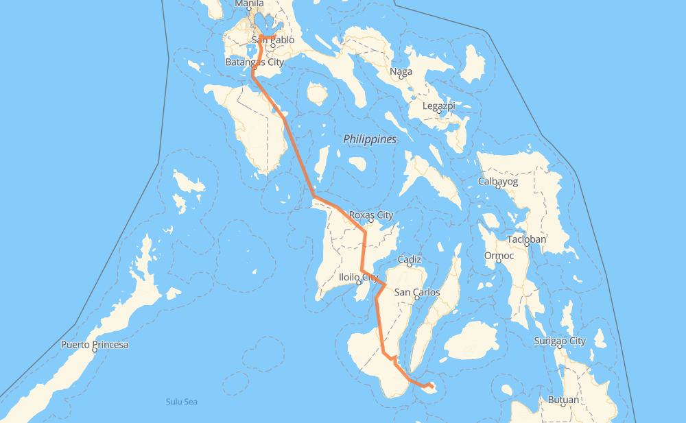
The distance from Maria to San Francisco is 531 miles by road including 31 miles on motorways. Road takes approximately 17 hours and 37 minutes and goes through Dumaguete, Kabankalan, Himamaylan, La Carlota, Bacólod, City of Passi and Calapan.
You can adjust fuel consumption and fuel price here.
How long is a car ride from Maria to San Francisco?
Driving time:
17 h 37 min
This time is calculated for driving at the maximum permitted speed, taking into account traffic rules restrictions.
29 mi with a maximum speed 62 mph = 28 min
47 mi with a maximum speed 56 mph = 49 min
319 mi with a maximum speed 50 mph = 6 h 24 min
5 mi with a maximum speed 43 mph = 6 min
7 mi with a maximum speed 37 mph = 10 min
6 mi with a maximum speed 31 mph = 11 min
4 mi with a maximum speed 25 mph = 8 min
1 mi with a maximum speed 19 mph = 3 min
114 mi with a maximum speed 12 mph = 9 h 13 min
The calculated driving time does not take into account intermediate stops and traffic jams.
How far is Maria to San Francisco by land?
The distance between Maria and San Francisco is 531.3 mi by road including 31.1 mi on motorways.
Precise satellite coordinates of highways were used for this calculation. The start and finish points are the centers of Maria and San Francisco respectively.
How far is Maria to San Francisco by plane?
The shortest distance (air line, as the crow flies) between Maria and San Francisco is 380.3 mi.
This distance is calculated using the Haversine formula as a great-circle distance between two points on the surface of a sphere. The start and finish points are the centers of Maria and San Francisco respectively. Actual distance between airports may be different.
How many hours is Maria from San Francisco by plane?
Boeing 737 airliner needs 45 min to cover the distance of 380 mi at a cruising speed of 497 mph.
Small plane "Cessna 172" needs 2 h 46 min to flight this distance at average speed of 136 mph.
This time is approximate and do not take into account takeoff and landing times, airport location and other real world factors.
How long is a helicopter ride from Maria to San Francisco?
Fast helicopter "Eurocopter AS350" or "Hughes OH-6 Cayuse" need 2 h 33 min to cover the distance of 380 mi at a cruising speed of 149 mph.
Popular "Robinson R44" needs 2 h 54 min to flight this distance at average speed of 130 mph.
This time is approximate and do not take into account takeoff and landing times, aerodrome location and other real world factors.
What city is halfway between Maria and San Francisco?
The halfway point between Maria and San Francisco is Balete. It is located about 1 mi from the exact midpoint by road.
The distance from Balete to Maria is 267 mi and driving will take about 7 h 17 min. The road between Balete and San Francisco has length 265 mi and will take approximately 10 h 19 min.
The other cities located close to halfway point:
Batan is in 261 mi from Maria and 270 mi from San Francisco
Banga is in 273 mi from Maria and 258 mi from San Francisco
Kalibo is in 276 mi from Maria and 255 mi from San Francisco
Where is Maria in relation to San Francisco?
Maria is located 380 mi south-east of San Francisco.
Maria has geographic coordinates: latitude 9.19745, longitude 123.65428.
San Francisco has geographic coordinates: latitude 14.21199, longitude 121.34314.
Which highway goes from Maria to San Francisco?
The route from Maria to San Francisco follows 6, 452.