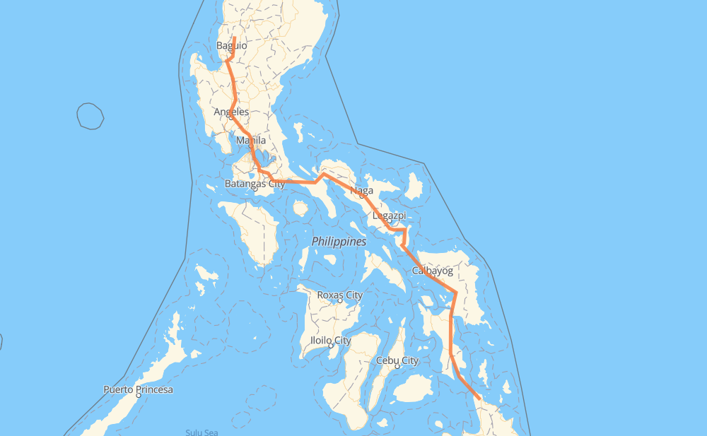
The distance from Kibungan to Upper Libas is 879 miles by road including 159 miles on motorways. Road takes approximately 19 hours and 59 minutes and goes through San Pedro, Biñan, Santa Rosa, Cabuyao, Calamba, San Pablo and Naga.
You can adjust fuel consumption and fuel price here.
How long is a car ride from Kibungan to Upper Libas?
Driving time:
19 h 59 min
This time is calculated for driving at the maximum permitted speed, taking into account traffic rules restrictions.
154 mi with a maximum speed 62 mph = 2 h 28 min
68 mi with a maximum speed 56 mph = 1 h 13 min
3 mi with a maximum speed 56 mph = 3 min
483 mi with a maximum speed 50 mph = 9 h 43 min
12 mi with a maximum speed 43 mph = 16 min
72 mi with a maximum speed 37 mph = 1 h 55 min
46 mi with a maximum speed 31 mph = 1 h 28 min
9 mi with a maximum speed 25 mph = 20 min
2 mi with a maximum speed 19 mph = 6 min
29 mi with a maximum speed 12 mph = 2 h 21 min
The calculated driving time does not take into account intermediate stops and traffic jams.
How far is Kibungan to Upper Libas by land?
The distance between Kibungan and Upper Libas is 878.6 mi by road including 159.1 mi on motorways.
Precise satellite coordinates of highways were used for this calculation. The start and finish points are the centers of Kibungan and Upper Libas respectively.
How far is Kibungan to Upper Libas by plane?
The shortest distance (air line, as the crow flies) between Kibungan and Upper Libas is 587.8 mi.
This distance is calculated using the Haversine formula as a great-circle distance between two points on the surface of a sphere. The start and finish points are the centers of Kibungan and Upper Libas respectively. Actual distance between airports may be different.
How many hours is Kibungan from Upper Libas by plane?
Boeing 737 airliner needs 1 h 10 min to cover the distance of 588 mi at a cruising speed of 497 mph.
Small plane "Cessna 172" needs 4 h 18 min to flight this distance at average speed of 136 mph.
This time is approximate and do not take into account takeoff and landing times, airport location and other real world factors.
How long is a helicopter ride from Kibungan to Upper Libas?
Fast helicopter "Eurocopter AS350" or "Hughes OH-6 Cayuse" need 3 h 56 min to cover the distance of 588 mi at a cruising speed of 149 mph.
Popular "Robinson R44" needs 4 h 30 min to flight this distance at average speed of 130 mph.
This time is approximate and do not take into account takeoff and landing times, aerodrome location and other real world factors.
What city is halfway between Kibungan and Upper Libas?
The halfway point between Kibungan and Upper Libas is Naga. It is located about 8 mi from the exact midpoint by road.
The distance from Naga to Kibungan is 432 mi and driving will take about 8 h 32 min. The road between Naga and Upper Libas has length 447 mi and will take approximately 11 h 26 min.
The other cities located close to halfway point:
Baao is in 448 mi from Kibungan and 431 mi from Upper Libas
San Fernando is in 426 mi from Kibungan and 453 mi from Upper Libas
Pamplona is in 420 mi from Kibungan and 459 mi from Upper Libas
Where is Kibungan in relation to Upper Libas?
Kibungan is located 588 mi north-west of Upper Libas.
Kibungan has geographic coordinates: latitude 16.69502, longitude 120.65509.
Upper Libas has geographic coordinates: latitude 9.65013, longitude 125.54557.
Which highway goes from Kibungan to Upper Libas?
The route from Kibungan to Upper Libas follows AH26, 1, E1.