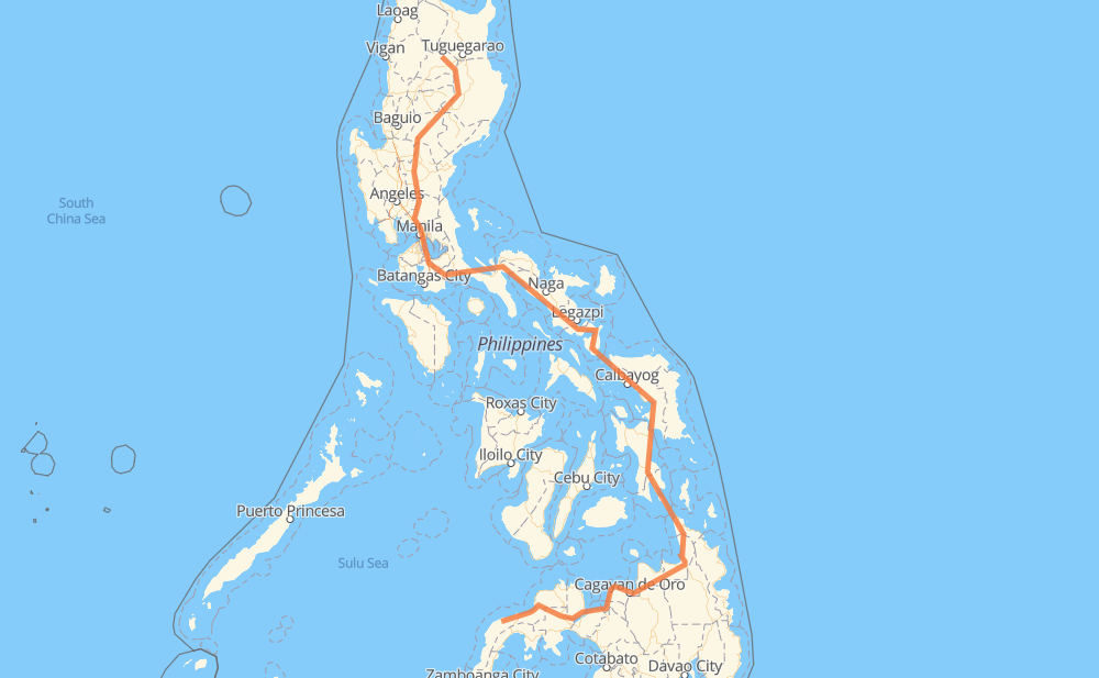
Distance between Gutalac and Pinukpuk
The distance from Gutalac to Pinukpuk is 1,361 miles by road including 48 miles on motorways. Road takes approximately 31 hours and 28 minutes and goes through Tangub, Ozamiz, Iligan, El Salvador, Gingoog, Butuan and Surigao City.
| Shortest distance by air | 667 mi ✈️ |
| Car route length | 1,361.4 mi 🚗 |
| Driving time | 31 h 28 min |
| Fuel amount | 46.3 gal |
| Fuel cost | 182 USD |
| Point | Distance | Time | Fuel | |
| Gutalac | 0 mi | 00 min | 0.0 gal | |
|
965 120 mi, 2 h 29 min
|
||||
| Tangub | 120 mi | 2 h 29 min | 4.1 gal | |
|
78 9 mi, 11 min
|
||||
| Ozamiz | 129 mi | 2 h 40 min | 4.4 gal | |
|
78 9 37 mi, 1 h 06 min
|
||||
| Iligan | 166 mi | 3 h 46 min | 5.6 gal | |
|
9 45 mi, 1 h 13 min
|
||||
| El Salvador | 211 mi | 4 h 59 min | 7.0 gal | |
|
9 955 71 mi, 1 h 32 min
|
||||
| Gingoog | 282 mi | 6 h 32 min | 9.5 gal | |
|
9 45 mi, 1 h 12 min
|
||||
| Butuan | 327 mi | 7 h 44 min | 11.1 gal | |
|
9 AH26 75 mi, 1 h 36 min
|
||||
| Surigao City | 402 mi | 9 h 21 min | 13.6 gal | |
|
1 142 mi, 3 h 50 min
|
||||
| Tacloban | 544 mi | 13 h 12 min | 18.4 gal | |
|
1 62 mi, 1 h 22 min
|
||||
| Catbalogan | 606 mi | 14 h 35 min | 20.3 gal | |
|
1 52 mi, 1 h 15 min
|
||||
| Calbayog | 657 mi | 15 h 50 min | 21.8 gal | |
|
1 90 mi, 2 h 43 min
|
||||
| Sorsogon City | 748 mi | 18 h 34 min | 25.4 gal | |
|
1 50 mi, 1 h 00 min
|
||||
| Ligao | 798 mi | 19 h 34 min | 27.1 gal | |
|
1 38 mi, 51 min
|
||||
| Naga | 836 mi | 20 h 26 min | 28.4 gal | |
|
1 187 mi, 3 h 55 min
|
||||
| San Pablo | 1,023 mi | 24 h 21 min | 34.7 gal | |
|
1 AH26 21 mi, 25 min
|
||||
| Calamba | 1,045 mi | 24 h 47 min | 35.4 gal | |
|
E2 4 mi, 03 min
|
||||
| Cabuyao | 1,048 mi | 24 h 50 min | 35.6 gal | |
|
E2 2 mi, 01 min
|
||||
| Santa Rosa | 1,050 mi | 24 h 52 min | 35.7 gal | |
|
E2 4 mi, 03 min
|
||||
| Biñan | 1,054 mi | 24 h 56 min | 35.8 gal | |
|
E2 3 mi, 03 min
|
||||
| San Pedro | 1,058 mi | 25 h 00 min | 35.9 gal | |
|
E2 AH26 73 mi, 1 h 26 min
|
||||
| Gapan | 1,131 mi | 26 h 26 min | 38.3 gal | |
|
1 30 mi, 39 min
|
||||
| Muñoz | 1,161 mi | 27 h 06 min | 39.4 gal | |
|
1 178 mi, 3 h 54 min
|
||||
| Tabuk | 1,340 mi | 31 h 00 min | 45.6 gal | |
|
52 222 25 mi, 27 min
|
||||
| Pinukpuk | 1,365 mi | 31 h 28 min | 46.3 gal | |
Frequently Asked Questions
How much does it cost to drive from Gutalac to Pinukpuk?
Fuel cost: 182 USD
This fuel cost is calculated as: (Route length 1,361.4 mi) / (Fuel consumption 29.4 mpg) * (Fuel price 3.93 USD / gal)
You can adjust fuel consumption and fuel price here.
How long is a car ride from Gutalac to Pinukpuk?
Driving time: 31 h 28 min
This time is calculated for driving at the maximum permitted speed, taking into account traffic rules restrictions.
- 42 mi with a maximum speed 62 mph = 40 min
- 206 mi with a maximum speed 56 mph = 3 h 40 min
- 3 mi with a maximum speed 56 mph = 3 min
- 749 mi with a maximum speed 50 mph = 15 h 4 min
- 25 mi with a maximum speed 43 mph = 34 min
- 237 mi with a maximum speed 37 mph = 6 h 21 min
- 51 mi with a maximum speed 31 mph = 1 h 38 min
- 15 mi with a maximum speed 25 mph = 36 min
- 5 mi with a maximum speed 19 mph = 15 min
- 32 mi with a maximum speed 12 mph = 2 h 33 min
The calculated driving time does not take into account intermediate stops and traffic jams.
How far is Gutalac to Pinukpuk by land?
The distance between Gutalac and Pinukpuk is 1,361.4 mi by road including 47.8 mi on motorways.
Precise satellite coordinates of highways were used for this calculation. The start and finish points are the centers of Gutalac and Pinukpuk respectively.
How far is Gutalac to Pinukpuk by plane?
The shortest distance (air line, as the crow flies) between Gutalac and Pinukpuk is 666.7 mi.
This distance is calculated using the Haversine formula as a great-circle distance between two points on the surface of a sphere. The start and finish points are the centers of Gutalac and Pinukpuk respectively. Actual distance between airports may be different.
How many hours is Gutalac from Pinukpuk by plane?
Boeing 737 airliner needs 1 h 20 min to cover the distance of 667 mi at a cruising speed of 497 mph.
Small plane "Cessna 172" needs 4 h 52 min to flight this distance at average speed of 136 mph.
This time is approximate and do not take into account takeoff and landing times, airport location and other real world factors.
How long is a helicopter ride from Gutalac to Pinukpuk?
Fast helicopter "Eurocopter AS350" or "Hughes OH-6 Cayuse" need 4 h 28 min to cover the distance of 667 mi at a cruising speed of 149 mph.
Popular "Robinson R44" needs 5 h 6 min to flight this distance at average speed of 130 mph.
This time is approximate and do not take into account takeoff and landing times, aerodrome location and other real world factors.
What city is halfway between Gutalac and Pinukpuk?
The halfway point between Gutalac and Pinukpuk is San JUan. It is located about 2 mi from the exact midpoint by road.
The distance from San JUan to Gutalac is 683 mi and driving will take about 16 h 19 min. The road between San JUan and Pinukpuk has length 679 mi and will take approximately 15 h 8 min.
The other cities located close to halfway point:
Where is Gutalac in relation to Pinukpuk?
Gutalac is located 667 mi south of Pinukpuk.
Gutalac has geographic coordinates: latitude 7.98534, longitude 122.40602.
Pinukpuk has geographic coordinates: latitude 17.57599, longitude 121.36745.
Which highway goes from Gutalac to Pinukpuk?
The route from Gutalac to Pinukpuk follows AH26, 1, 9.
Other minor sections pass along the road:
- 68: 58 mi
- 51: 50 mi
- 955: 43 mi
- 965: 38 mi
- E2: 32 mi
- 78: 30 mi
- 79: 29 mi
- 691: 24 mi
- 222: 17 mi
- E1: 14 mi
- 52: 8 mi
- 609: 5 mi
- 140: 3 mi
- 673: 2 mi
- 160: 2 mi
- 608: 2 mi
- 145: 1 mi
- 161: 1 mi