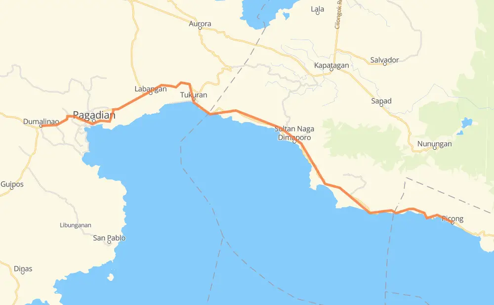
Distance between Dumalinao and Picong
The distance from Dumalinao to Picong is 53 miles by road. Road takes approximately 1 hour and 21 minutes and goes through Pagadian, Labangan, Tukuran, Sultan Naga Dimaporo and Imelda.
| Shortest distance by air | 40 mi ✈️ |
| Car route length | 52.8 mi 🚗 |
| Driving time | 1 h 21 min |
| Fuel amount | 1.8 gal |
| Fuel cost | 7 USD |
| Point | Distance | Time | Fuel | |
| Dumalinao | 0 mi | 00 min | 0.0 gal | |
|
1 6 mi, 09 min
|
||||
| Pagadian | 6 mi | 09 min | 0.0 gal | |
|
1 7 mi, 10 min
|
||||
| Labangan | 14 mi | 20 min | 0.4 gal | |
|
1 7 mi, 09 min
|
||||
| Tukuran | 21 mi | 29 min | 0.5 gal | |
|
1 12 mi, 19 min
|
||||
| Sultan Naga Dimaporo | 33 mi | 49 min | 1.0 gal | |
|
1 20 mi, 32 min
|
||||
| Picong | 53 mi | 1 h 21 min | 1.6 gal | |
Frequently Asked Questions
How much does it cost to drive from Dumalinao to Picong?
Fuel cost: 7 USD
This fuel cost is calculated as: (Route length 52.8 mi) / (Fuel consumption 29.4 mpg) * (Fuel price 3.93 USD / gal)
You can adjust fuel consumption and fuel price here.
How long is a car ride from Dumalinao to Picong?
Driving time: 1 h 21 min
This time is calculated for driving at the maximum permitted speed, taking into account traffic rules restrictions.
- 14 mi with a maximum speed 50 mph = 16 min
- 34 mi with a maximum speed 37 mph = 54 min
- 4 mi with a maximum speed 31 mph = 6 min
- 1 mi with a maximum speed 25 mph = 3 min
The calculated driving time does not take into account intermediate stops and traffic jams.
How far is Dumalinao to Picong by land?
The distance between Dumalinao and Picong is 52.8 mi by road.
Precise satellite coordinates of highways were used for this calculation. The start and finish points are the centers of Dumalinao and Picong respectively.
How far is Dumalinao to Picong by plane?
The shortest distance (air line, as the crow flies) between Dumalinao and Picong is 40.4 mi.
This distance is calculated using the Haversine formula as a great-circle distance between two points on the surface of a sphere. The start and finish points are the centers of Dumalinao and Picong respectively. Actual distance between airports may be different.
How many hours is Dumalinao from Picong by plane?
Boeing 737 airliner needs 4 min to cover the distance of 40 mi at a cruising speed of 497 mph.
Small plane "Cessna 172" needs 17 min to flight this distance at average speed of 136 mph.
This time is approximate and do not take into account takeoff and landing times, airport location and other real world factors.
How long is a helicopter ride from Dumalinao to Picong?
Fast helicopter "Eurocopter AS350" or "Hughes OH-6 Cayuse" need 16 min to cover the distance of 40 mi at a cruising speed of 149 mph.
Popular "Robinson R44" needs 18 min to flight this distance at average speed of 130 mph.
This time is approximate and do not take into account takeoff and landing times, aerodrome location and other real world factors.
What city is halfway between Dumalinao and Picong?
The halfway point between Dumalinao and Picong is Tukuran. It is located about 6 mi from the exact midpoint by road.
The distance from Tukuran to Dumalinao is 21 mi and driving will take about 29 min. The road between Tukuran and Picong has length 32 mi and will take approximately 51 min.
The other cities located close to halfway point:
Where is Dumalinao in relation to Picong?
Dumalinao is located 40 mi west of Picong.
Dumalinao has geographic coordinates: latitude 7.81832, longitude 123.36299.
Picong has geographic coordinates: latitude 7.68472, longitude 123.93596.
Which highway goes from Dumalinao to Picong?
The route from Dumalinao to Picong follows 1, AH26.