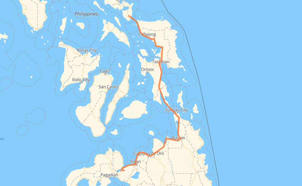
The distance from Buenavista to Magsaysay is 602 miles by road. Road takes approximately 15 hours and 29 minutes and goes through Calbayog, Catbalogan, Tacloban, Surigao City, Butuan, Gingoog and El Salvador.
You can adjust fuel consumption and fuel price here.
How long is a car ride from Buenavista to Magsaysay?
Driving time:
15 h 29 min
This time is calculated for driving at the maximum permitted speed, taking into account traffic rules restrictions.
97 mi with a maximum speed 56 mph = 1 h 43 min
3 mi with a maximum speed 56 mph = 3 min
237 mi with a maximum speed 50 mph = 4 h 45 min
3 mi with a maximum speed 43 mph = 3 min
210 mi with a maximum speed 37 mph = 5 h 38 min
21 mi with a maximum speed 31 mph = 41 min
4 mi with a maximum speed 25 mph = 9 min
2 mi with a maximum speed 19 mph = 5 min
29 mi with a maximum speed 12 mph = 2 h 17 min
The calculated driving time does not take into account intermediate stops and traffic jams.
How far is Buenavista to Magsaysay by land?
The distance between Buenavista and Magsaysay is 602.1 mi by road.
Precise satellite coordinates of highways were used for this calculation. The start and finish points are the centers of Buenavista and Magsaysay respectively.
How far is Buenavista to Magsaysay by plane?
The shortest distance (air line, as the crow flies) between Buenavista and Magsaysay is 322.5 mi.
This distance is calculated using the Haversine formula as a great-circle distance between two points on the surface of a sphere. The start and finish points are the centers of Buenavista and Magsaysay respectively. Actual distance between airports may be different.
How many hours is Buenavista from Magsaysay by plane?
Boeing 737 airliner needs 38 min to cover the distance of 322 mi at a cruising speed of 497 mph.
Small plane "Cessna 172" needs 2 h 21 min to flight this distance at average speed of 136 mph.
This time is approximate and do not take into account takeoff and landing times, airport location and other real world factors.
How long is a helicopter ride from Buenavista to Magsaysay?
Fast helicopter "Eurocopter AS350" or "Hughes OH-6 Cayuse" need 2 h 9 min to cover the distance of 322 mi at a cruising speed of 149 mph.
Popular "Robinson R44" needs 2 h 28 min to flight this distance at average speed of 130 mph.
This time is approximate and do not take into account takeoff and landing times, aerodrome location and other real world factors.
What city is halfway between Buenavista and Magsaysay?
The halfway point between Buenavista and Magsaysay is Benit. It is located about 1 mi from the exact midpoint by road.
The distance from Benit to Buenavista is 300 mi and driving will take about 7 h 24 min. The road between Benit and Magsaysay has length 303 mi and will take approximately 8 h 4 min.
The other cities located close to halfway point:
San Ricardo is in 299 mi from Buenavista and 303 mi from Magsaysay
Balong-balong is in 296 mi from Buenavista and 306 mi from Magsaysay
Lobo is in 295 mi from Buenavista and 308 mi from Magsaysay
Where is Buenavista in relation to Magsaysay?
Buenavista is located 322 mi north of Magsaysay.
Buenavista has geographic coordinates: latitude 12.69997, longitude 124.02444.
Magsaysay has geographic coordinates: latitude 8.03528, longitude 123.9126.
Which highway goes from Buenavista to Magsaysay?
The route from Buenavista to Magsaysay follows 1, AH26, 9.