Distance between Badoc and Pantukan
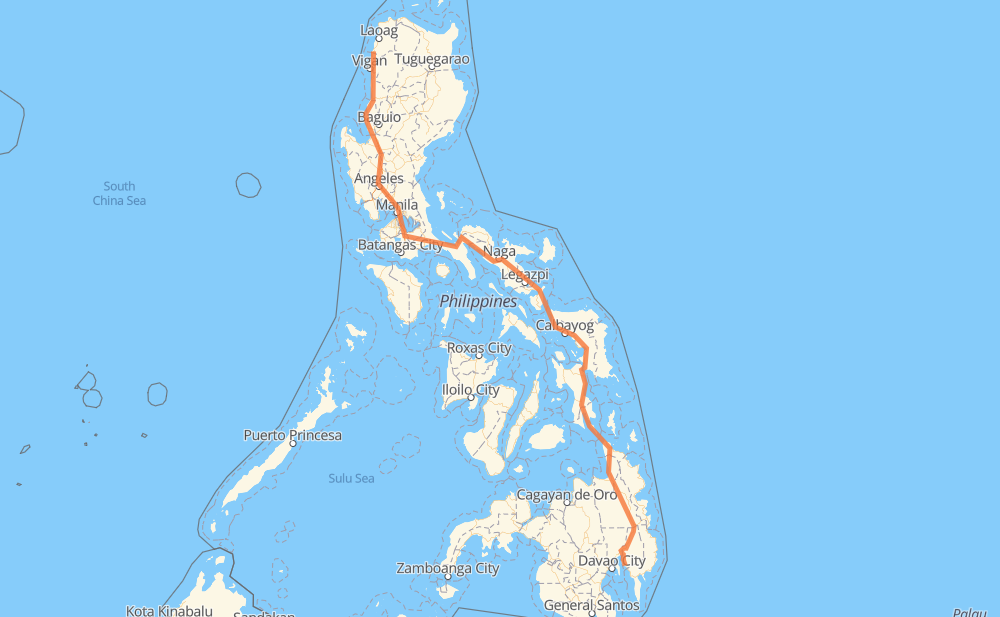
The distance from Badoc to Pantukan is 1,184 miles by road including 159 miles on motorways. Road takes approximately 26 hours and 41 minutes and goes through Candon, San Fernando, San Pedro, Biñan, Santa Rosa, Cabuyao and Calamba.
| Shortest distance by air | 831 mi ✈️ |
| Car route length | 1,183.7 mi 🚗 |
| Driving time | 26 h 41 min |
| Fuel amount | 40.3 gal |
| Fuel cost | 157 USD |
| Point | Distance | Time | Fuel | |
| Badoc | 0 mi | 00 min | 0.0 gal | |
|
2 65 mi, 1 h 31 min
|
||||
| Candon | 65 mi | 1 h 31 min | 2.1 gal | |
|
2 47 mi, 1 h 07 min
|
||||
| San Fernando | 112 mi | 2 h 39 min | 3.8 gal | |
|
2 E1 183 mi, 3 h 25 min
|
||||
| San Pedro | 295 mi | 6 h 04 min | 10.0 gal | |
|
E2 3 mi, 03 min
|
||||
| Biñan | 298 mi | 6 h 08 min | 10.1 gal | |
|
E2 4 mi, 03 min
|
||||
| Santa Rosa | 302 mi | 6 h 11 min | 10.2 gal | |
|
E2 2 mi, 01 min
|
||||
| Cabuyao | 304 mi | 6 h 13 min | 10.3 gal | |
|
E2 4 mi, 03 min
|
||||
| Calamba | 308 mi | 6 h 17 min | 10.4 gal | |
|
E2 AH26 22 mi, 26 min
|
||||
| San Pablo | 329 mi | 6 h 43 min | 11.1 gal | |
|
1 187 mi, 3 h 55 min
|
||||
| Naga | 516 mi | 10 h 39 min | 17.5 gal | |
|
1 38 mi, 51 min
|
||||
| Ligao | 554 mi | 11 h 30 min | 18.8 gal | |
|
1 50 mi, 1 h 00 min
|
||||
| Sorsogon City | 605 mi | 12 h 31 min | 20.5 gal | |
|
1 90 mi, 2 h 43 min
|
||||
| Calbayog | 695 mi | 15 h 14 min | 23.1 gal | |
|
1 52 mi, 1 h 15 min
|
||||
| Catbalogan | 747 mi | 16 h 29 min | 25.1 gal | |
|
1 62 mi, 1 h 22 min
|
||||
| Tacloban | 809 mi | 17 h 52 min | 27.4 gal | |
|
1 142 mi, 3 h 50 min
|
||||
| Surigao City | 951 mi | 21 h 43 min | 32.3 gal | |
|
1 86 mi, 1 h 54 min
|
||||
| Bayugan | 1,037 mi | 23 h 38 min | 34.8 gal | |
|
1 147 mi, 3 h 02 min
|
||||
| Pantukan | 1,184 mi | 26 h 41 min | 40.2 gal | |
Frequently Asked Questions
How much does it cost to drive from Badoc to Pantukan?
Fuel cost: 157 USD
This fuel cost is calculated as: (Route length 1,183.7 mi) / (Fuel consumption 29.4 mpg) * (Fuel price 3.9 USD / gal)
You can adjust fuel consumption and fuel price here.
How long is a car ride from Badoc to Pantukan?
Driving time: 26 h 41 min
This time is calculated for driving at the maximum permitted speed, taking into account traffic rules restrictions.
- 154 mi with a maximum speed 62 mph = 2 h 28 min
- 108 mi with a maximum speed 56 mph = 1 h 55 min
- 3 mi with a maximum speed 56 mph = 3 min
- 675 mi with a maximum speed 50 mph = 13 h 34 min
- 12 mi with a maximum speed 43 mph = 16 min
- 146 mi with a maximum speed 37 mph = 3 h 54 min
- 33 mi with a maximum speed 31 mph = 1 h 4 min
- 16 mi with a maximum speed 25 mph = 37 min
- 7 mi with a maximum speed 19 mph = 24 min
- 29 mi with a maximum speed 12 mph = 2 h 21 min
The calculated driving time does not take into account intermediate stops and traffic jams.
How far is Badoc to Pantukan by land?
The distance between Badoc and Pantukan is 1,183.7 mi by road including 159.1 mi on motorways.
Precise satellite coordinates of highways were used for this calculation. The start and finish points are the centers of Badoc and Pantukan respectively.
How far is Badoc to Pantukan by plane?
The shortest distance (air line, as the crow flies) between Badoc and Pantukan is 830.8 mi.
This distance is calculated using the Haversine formula as a great-circle distance between two points on the surface of a sphere. The start and finish points are the centers of Badoc and Pantukan respectively. Actual distance between airports may be different.
How many hours is Badoc from Pantukan by plane?
Boeing 737 airliner needs 1 h 40 min to cover the distance of 831 mi at a cruising speed of 497 mph.
Small plane "Cessna 172" needs 6 h 4 min to flight this distance at average speed of 136 mph.
This time is approximate and do not take into account takeoff and landing times, airport location and other real world factors.
How long is a helicopter ride from Badoc to Pantukan?
Fast helicopter "Eurocopter AS350" or "Hughes OH-6 Cayuse" need 5 h 34 min to cover the distance of 831 mi at a cruising speed of 149 mph.
Popular "Robinson R44" needs 6 h 22 min to flight this distance at average speed of 130 mph.
This time is approximate and do not take into account takeoff and landing times, aerodrome location and other real world factors.
What city is halfway between Badoc and Pantukan?
The halfway point between Badoc and Pantukan is Al Lacesdaster. It is located about 4 mi from the exact midpoint by road.
The distance from Al Lacesdaster to Badoc is 597 mi and driving will take about 12 h 17 min. The road between Al Lacesdaster and Pantukan has length 587 mi and will take approximately 14 h 23 min.
The other cities located close to halfway point:
Where is Badoc in relation to Pantukan?
Badoc is located 831 mi north-west of Pantukan.
Badoc has geographic coordinates: latitude 17.9267, longitude 120.47409.
Pantukan has geographic coordinates: latitude 7.13145, longitude 125.8973.
Which highway goes from Badoc to Pantukan?
The route from Badoc to Pantukan follows AH26, 1, 2, E1.
Other minor sections pass along the road:
- 68: 58 mi
- E2: 32 mi
- 74: 24 mi
- 691: 24 mi
- 609: 5 mi
- 140: 3 mi
- 160: 2 mi
- 673: 2 mi
- 608: 2 mi
- 145: 2 mi
- 161: 1 mi